The wonders of space exploration have transcended beyond the boundaries of our planet, delivering remarkable benefits to Earth.
Among these, space technology has emerged as a powerful tool in preserving our oceans and fostering sustainable practices. In this article, we delve into the profound advantages of space technology, highlighting its role in combating climate change, safeguarding marine ecosystems, and promoting responsible resource management.
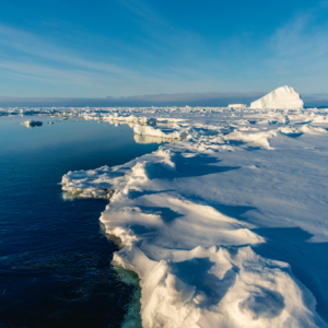
Satellite Mapping and Monitoring: Illuminating Marine Ecosystems
Unveiling Marine Environments
Equipped with advanced sensors and imaging capabilities, space satellites offer a unique vantage point for mapping and monitoring our planet’s oceans. This valuable perspective enables scientists to comprehensively study and understand natural and protected marine areas, generating crucial data for conservation efforts.
Tracking Climate Change Impacts
Space technology plays a pivotal role in monitoring the effects of climate change on marine environments. Satellites accurately measure sea surface temperatures, ocean currents, and other vital parameters, providing scientists with indispensable data.
This information aids in predicting shifts in oceanic patterns, sea levels, and long-term consequences of global warming. Armed with this knowledge, stakeholders and policymakers can make informed decisions to mitigate climate change effects and protect vulnerable marine habitats.
Space technology aids in the effective management of marine resources by monitoring fishing activities. Satellites track fishing vessels, enabling authorities to combat illegal, unreported, and unregulated fishing practices. Through the enforcement of regulations, protection of endangered species, and ensuring sustainable fish stocks, space technology promotes responsible fishing practices, maintaining the delicate balance of marine ecosystems.
Algal Bloom Detection and Prevention: Safeguarding Marine Life
Harmful algal bloom detected off the Cornish coast. Credit: PML (Plymouth Marine Laboratory).
Satellites equipped with high-resolution cameras possess the ability to detect and track algal blooms—excessive accumulations of algae that wreak havoc on marine ecosystems.
These blooms lead to oxygen depletion and the release of harmful toxins, endangering aquatic organisms. Early identification through satellite monitoring empowers authorities to implement preventive measures, effectively curbing their impact and preserving biodiversity.
Coral Reef Mapping and Conservation: Preserving Biodiversity Hotspots
Satellite mapping techniques enable the comprehensive monitoring and mapping of coral reefs worldwide. By utilizing high-resolution imagery, scientists can assess the health and extent of coral reef ecosystems, aiding in conservation efforts and the preservation of these crucial biodiversity hotspots.
Tagged humpback whales: A way to study marine life. BBC Credit: Joanna Kershaw / University Of St Andrews
“Most projects that support the oceans use mainly Earth observation data, but telecommunications satellites can also support marine life. This was demonstrated by the SHARC project that developed tracking devices for marine animals. The devices have already been tested on tiger sharks and are much cheaper and longer-lasting than more traditional trackers”, said the European Space Agency. Read their full article here.
By incorporating advanced telecommunications satellite technology into animal tracking initiatives, scientists can gain crucial insights into the movement patterns, behavior, and habitats of marine species. This enhanced understanding not only aids in conservation efforts but also contributes to the broader understanding of marine ecosystems and the preservation of biodiversity.
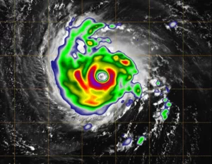
Disaster Response and Recovery: Safeguarding Coastal Communities
Hurricane Florence as seen from a CubeSat. Credit: NASA/NOAA/Naval Research Laboratory Monterey/JPL-Caltech
Space technology enhances our capacity to respond to natural disasters and environmental emergencies in marine environments. Satellites provide real-time data on oceanic conditions, including storm formation, ocean currents, and water temperature. This information enables accurate prediction and tracking of hurricanes, typhoons, and tsunamis. Timely warnings, efficient evacuation plans, and resource mobilization for disaster response and recovery efforts are made possible through space technology, ensuring the safety of coastal communities.
As seen in the image below, NASA launched two small satellites designed to track tropical cyclones hour by hour, in a project that could improve weather predictions on devastating storms. This image combines NASA’s TEMPEST-D data with a visible image of the storm from NASA’s GOES weather satellite revealing the eye of the storm surrounded by towering, intense rain bands.
Ocean Acidification Monitoring: A Vital Climate Change Indicator
Space technology assists in monitoring and understanding the phenomenon of ocean acidification, which occurs due to increased carbon dioxide absorption by the oceans. Satellites provide data on pH levels and carbonate chemistry, allowing scientists to assess the impact of acidification on marine ecosystems and the organisms that rely on them.
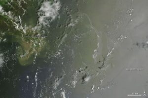
Oil Spill Detection and Response: Rapid Environmental Monitoring
Satellites equipped with specialized sensors can identify and monitor oil spills in marine environments. This early detection enables swift response measures to mitigate the environmental impact, protect marine life, and prevent further damage to sensitive coastal ecosystems.
The image to the left shows the oil slick in the Gulf of Mexico, July 2010, captured by NASA’s Terra satellite image.
“A silvery-gray streak of oil remained visible offshore of the Mississippi River Delta. The tan-colored waters around the river delta are full of sediment”, said NASA
Space technology plays a role in monitoring and assessing underwater noise levels, which can have detrimental effects on marine life, including marine mammals and fish species. By understanding the sources and impact of underwater noise pollution, stakeholders can implement measures to mitigate its effects and protect marine habitats.
This data assists in identifying the sources of pollution, implementing effective waste management strategies, and raising awareness about the urgency of combating ocean plastic pollution.
Oceanographic Research and Modeling: Enhancing Scientific Understanding
Space technology supports oceanographic research by providing critical data on ocean currents, salinity, chlorophyll levels, and other essential parameters. This data enables scientists to develop accurate models and simulations to better understand the complex dynamics of marine ecosystems and predict their future behavior.
Blue Economy Opportunities: Supporting Sustainable Ocean-Based Industries
Space technology contributes to the sustainable development of ocean-based industries by providing data on weather patterns, ocean conditions, and marine resources. This information assists in optimizing activities such as fisheries, aquaculture, offshore energy, and tourism, while ensuring minimal impact on marine ecosystems.
Space technology, with its vast array of applications, has revolutionized our ability to preserve our oceans, combat climate change, and promote sustainable practices.
By harnessing the power of satellites, we can map and monitor marine ecosystems, track climate change impacts, detect algal blooms, monitor phenomena like ocean acidification and underwater noise pollution, and respond swiftly to oil spills. Furthermore, satellites aid in tracking marine debris, advancing oceanographic research, and supporting the development of sustainable ocean-based industries.
Through satellite monitoring and data collection, we gain invaluable insights into the health and dynamics of our oceans, allowing us to implement targeted conservation efforts, protect vulnerable species and habitats, and make informed decisions regarding resource management. These advancements enable us to address environmental challenges such as climate change, plastic pollution, and overfishing, while also fostering sustainable economic development through the blue economy.
As we continue to explore the mysteries of space, it is essential to recognize the immense value of our oceans and marine resources. The delicate balance of our marine ecosystems is crucial for the well-being of our planet and future generations. By embracing the wonders of space technology and combining scientific knowledge with responsible action, we can safeguard our oceans, preserve biodiversity, and ensure a sustainable future for all.
 Space technology plays a pivotal role in monitoring the effects of climate change on marine environments. Satellites accurately measure sea surface temperatures, ocean currents, and other vital parameters, providing scientists with indispensable data.
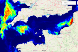
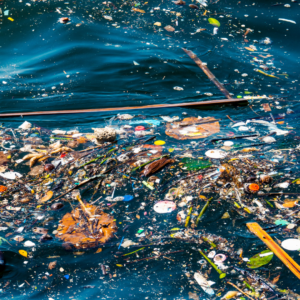 Satellites aid in tracking the movement and accumulation of marine debris, including plastic pollution, across vast oceanic regions.