Chile's Devastating Wildfires: CAMS Monitoring Reveals Alarming Carbon Emissions
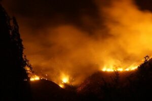
In recent days, central and southern Chile have been experiencing dozens of devastating wildfires.
The dry weather, high temperatures, and strong winds in the area have exacerbated the situation, leading to a spike in emissions into the atmosphere. As a result, a large smoke plume has been transported across the Pacific Ocean. According to local officials, the wildfires have caused at least 26 fatalities, almost 1,000 injuries, and have affected over 270,000 hectares of territory.
The Copernicus Atmosphere Monitoring Service (CAMS) has been closely monitoring the situation and assessing the impact on the atmosphere.
CAMS Senior Scientist Mark Parrington stated, “Drier and hotter conditions in the region have increased the risk of vegetation fires, which has resulted in a large number of fast-developing large-scale fires. The high intensity of these fires is reflected in the emissions and the size of the smoke plumes being transported out to the Pacific that we have been monitoring.”
CAMS has been using its Global Fire Assimilation System (GFAS) to provide data on the distribution, daily total intensity, and corresponding emissions to the atmosphere of the observed fire activity. CAMS has also been monitoring the evolution and transport of the large smoke plumes originating from the fires.
The CAMS monitoring of wildfire carbon emissions reveals that between January and February of this year, almost 4 megatonnes of carbon were emitted, making it the second-highest level of wildfire carbon emissions in Chile for these months in the past 20 years. The regions of Bio-Bío, La Araucanía, and Ñuble have recorded the highest emission levels in the past 20 years, with carbon emissions in January and February amounting to over 2.5 megatonnes, 1.4 megatonnes, and 0.7 megatonnes, respectively. Emissions from Bio-Bío and La Araucanía are more than double their previous record levels, set in 2017 in Bio-Bío and 2008 in La Araucanía.
The CAMS monitoring of total fire radiative power (FRP) indicates a spike in FRP between 4-6 February, well above the mean of the 2003-2022 data and corresponding to the situation on the ground. The Global ECMWF Fire Forecast map of fire danger forecast shows extreme fire danger across a large area of Chile and Argentina. Satellite observations from the NASA Moderate Resolution Imaging Spectroradiometer (MODIS) sensors during the prior seven days show the fires in southern and central Chile occurring in areas with the highest fire risk.
The impact of the wildfires on the atmosphere is significant, with prevailing winds carrying a large smoke plume northwestwards from the affected area out into the Pacific Ocean, and a smaller plume being transported across central Argentina and out into the South Atlantic. The CAMS total aerosol optical depth 5-day forecast initialized on 7 February illustrates the extent of the impact.
The ongoing wildfires pose a significant threat to the environment, affected communities, and the atmosphere. Monitoring efforts by organizations like CAMS are critical in providing up-to-date information on the situation, assessing the impact of the fires, and assisting in efforts to combat and control the wildfires. As the situation continues to develop, ongoing monitoring and analysis will be essential in mitigating the impact of the wildfires on affected communities and the environment.